5 miles/hex map of the area between Castle Westguard and Castle Beldon:
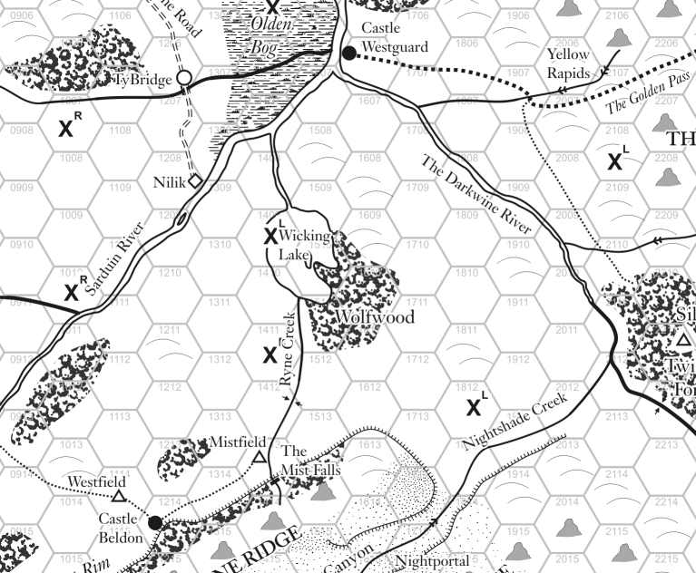 |
| 5 miles/hex |
Castle Westguard lies on the Sarduin River, which is navigable south upriver to Sam's Landing and north downriver to the Halflings of Dunshire and beyond to the lizardman and Trosk-infested swamplands of the coast. To the west is the Dwarf realm of Bolzak in the White Mountains, while the Elf refuge of the Twilight Forest lies south-east along the Darkwine river. To the south-west is the Orc realm of Blood Forest, that was formerly the Elf realm of Silverwood. To the east is the Golden Pass across the Westwall mountains to Hawksleigh and the Grand Kingdom.
To the south, Castle Beldon enjoys a strong position on the Sunset Rim beneath Redstone Ridge, and so far has easily repulsed attempts against it by the Grand Kingdom.
Castle Trionos
(120 miles) - King's Road - road - 3 days at 40 miles/day
Shreve Port
(160 miles) - Greenelm Woods - track - 6 days at 30 miles/day
Hawksleigh
(40 miles) - Golden Pass - difficult terrain - 2 days at 20 miles/day
Castle Westguard
Typical travel time is 20 miles/day on foot with a medium load, 30 miles/day by horse with no remount, 40 miles/day by horse with remount, or by carriage.
No comments:
Post a Comment